

By Julia Davis
May 28, 2024
Assistant professor part of NASA finalist team to study terrestrial and polar ecosystems with advanced satellite technology.

An aerial view of the Heimdal Glacier in southern Greenland. NASA/John Sonntag.
Assistant professor David Shean is part of a team that has been selected as a finalist for a $310 million NASA satellite mission. Shean is a co-investigator on the Earth Dynamics Geodetic Explorer (EDGE) team, which aims to revolutionize our understanding of terrestrial and polar ecosystems through advanced satellite technology.
EDGE is one of four proposals chosen by NASA under the new Earth System Explorers Program, designed to address critical Earth science priorities. The EDGE mission specifically focuses on observing the three-dimensional structure of terrestrial ecosystems like forests, and the surface features of glaciers, ice sheets and sea ice as they change in response to climate and human activity.
“We have the opportunity to scan rapidly changing areas of the Earth’s icy regions, including the Nisqually Glacier on Mount Rainier and other Pacific Northwest glaciers, providing insights into their evolution and current state.”
These observations are possible because of new satellite laser altimetry technology that will be able to provide detailed measurements of the Earth’s changing surface topography and vegetation.
Shean explains that the EDGE satellite will cover all latitudes, from dense rainforests to polar ice sheets, offering comprehensive global data.
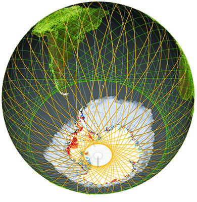
EDGE orbit (orange tracks) extends to the polar regions allowing for dense mapping around the edges of ice sheets and sea ice. Photo courtesy of EDGE
Shean is responsible for developing data fusion approaches to combine the accurate elevation measurements from EDGE with elevation measurements from other satellite images. As part of the land ice elevation team, he brings expertise in mountain glaciers and ice sheets.
The EDGE team is comprised of 25 scientists and engineers from around the world and is led by the Scripps Institution of Oceanography at the University of California, San Diego. Alongside Shean, Benjamin Smith, a senior research scientist at the UW's Applied Physics Laboratory, is also an investigator on the EDGE proposal.
“It’s incredibly exciting to be a member of this team, and I am thrilled to work with them to make EDGE technology a reality in the coming years,” Shean says.
The team will receive $5 million over the next year to further develop their mission concept. Following this, NASA will select two proposals from the finalists for full implementation, with launches scheduled for the early 2030s.
In addition to the EDGE mission, another University of Washington-led project, STRIVE, has also been named a finalist in the NASA Earth System Explorers Program. STRIVE aims to study the interactions between the stratosphere and troposphere, which are important for understanding atmospheric chemistry, circulation and climate processes.
For more information about the EDGE mission and other NASA Earth System Explorers Program finalists, visit NASA’s official announcement. Additional insights about the EDGE team and their innovative approach can also be found in UCSD’s announcement about the grant.